Blue Mars as seen by Fractal Terrains
A simple exploration of what happens if Mars gets flooded
with water to the 0 level of the MOLA Data Set. All images
on this page (and subpages with images and links) were
prepared in approximately 15 minutes using Fractal Terrains
from ProFantasy Software Ltd.
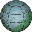
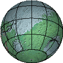
The spinning globes above were assembled using
Adobe ImageReady 2.0; the individual frames were generated
in two operations from Fractal Terrains. They show the north
and south polar areas centered at 25 degrees north and south
latitude.
Fractal Terrains can also generate VRML globes of worlds.
See here for an example. Requires a VRML 2.0 viewer to work.
And for those of you who just can't get enough, there is an HTML-
based browser/zoom sequence generated entirely by Fractal Terrains
can be viewed here. All maps are are in the Wagner IV projection.
Fractal Terrains can generate data in 13 projections, but web space
precludes including others here. Actually, the top level map HTML
file was editied to return to this page when the parent link was
clicked, but it is otherwise as generated.
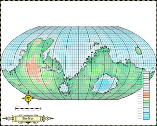
Finally, we include a basic Campaign Cartographer 2 (another fine
product from ProFantasy) map of Mars (shown above), also in
the Wagner IV projection. This map was compressed with
WinZip in order to save download space. It's still 860KB. If you
don't have CC2 version 6.x, pick up the CC2 map viewer from
the ProFantasy web site to see an example of unretouched
Fractal Terrains output.